|  Today turned out to be a short mileage day partly because I got
a really late start. Fortunately, the reason for that was I spent
a good part of the morning talking with a guy from Minnesota who
was hiking at various places in Wyoming and solo car camping.
He was 50'ish and was currently an unemployed print shop stripper.
I listened as he explained how he had seen the writing on the
wall as print shops went more and more digital but never really
did anything about it. He was now unemployed with a skill that
nobody wants and is looking for some direction. My stepfather
is also in the printing business and has some experience with
this same problem. Luckily he is retiring this year and will be
able to keep his job until that time. I wished this fellow the
best of luck in whatever he chose to do. He seemed well educated
and had a very positive attitude but his age is going to be a
hindrance.
Today turned out to be a short mileage day partly because I got
a really late start. Fortunately, the reason for that was I spent
a good part of the morning talking with a guy from Minnesota who
was hiking at various places in Wyoming and solo car camping.
He was 50'ish and was currently an unemployed print shop stripper.
I listened as he explained how he had seen the writing on the
wall as print shops went more and more digital but never really
did anything about it. He was now unemployed with a skill that
nobody wants and is looking for some direction. My stepfather
is also in the printing business and has some experience with
this same problem. Luckily he is retiring this year and will be
able to keep his job until that time. I wished this fellow the
best of luck in whatever he chose to do. He seemed well educated
and had a very positive attitude but his age is going to be a
hindrance.
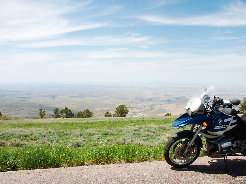
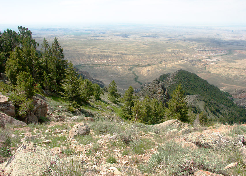
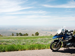
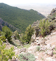
 I left
Cody and headed east on Alt 14 towards the Big Horn Mountains.
I was following a suggestion from I guy I met in Nebraska who
was originally from this area. He told me if I wanted to see some
impressive scenery, but without the crowds, I should head to the
Big Horns. So I did. You climb from the valley floor up to some
impressive altitudes and the views are worth the trip. I hear
that on clear days you can see over 100 miles and I believe it.
Even with the haze and clouds I could easily see tens of miles.
Other than the haze the weather was perfect for motorcycling being
neither too cold nor too hot. I left
Cody and headed east on Alt 14 towards the Big Horn Mountains.
I was following a suggestion from I guy I met in Nebraska who
was originally from this area. He told me if I wanted to see some
impressive scenery, but without the crowds, I should head to the
Big Horns. So I did. You climb from the valley floor up to some
impressive altitudes and the views are worth the trip. I hear
that on clear days you can see over 100 miles and I believe it.
Even with the haze and clouds I could easily see tens of miles.
Other than the haze the weather was perfect for motorcycling being
neither too cold nor too hot.
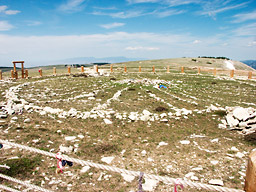 One place that I had read about and definitely wanted to visit
was Medicine Wheel National Monument. If you read the informational
signs it is written that nobody knows exactly when the medicine
wheel was built or its true purpose. Considering that native americans
still use it for ceremonies my guess is that the native americans
know its true purpose but they aren't talking. I certainly don't
blame them and even if they did try and explain I am almost positive
it would be lost on on anybody not of their people.
One place that I had read about and definitely wanted to visit
was Medicine Wheel National Monument. If you read the informational
signs it is written that nobody knows exactly when the medicine
wheel was built or its true purpose. Considering that native americans
still use it for ceremonies my guess is that the native americans
know its true purpose but they aren't talking. I certainly don't
blame them and even if they did try and explain I am almost positive
it would be lost on on anybody not of their people.
 This from a web site: "The wheel measures approximately 80 feet
in diameter and has an approximately 245 foot circumference. The
wheel became a National Historic Landmark in 1970. There is no
exact date to when the wheel was constructed. There are many legends
of the wheel but there is no real way to tell why it was built.
The wheel looks to have been carefully designed and constructed.
It is made up of seven cairns (a heap of stones set up as a landmark
or monument). From the center cairn, 28 spokes outstretch to the
outer rim. Six of the cairns are placed in varied locations on
the edge or rim of the wheel. These six cairns are smaller than
the center cairn. Only five of the cairns actually touch the rim
of the wheel. One of the remaining two cairns faces the north
and the other faces the east. The center cairn measures approximately
12 feet by 7 feet. Some believe that the cairns may have been
covered with skins supported by wooden poles. The wheel was probably
built between 1200 and 1700 A.D."
This from a web site: "The wheel measures approximately 80 feet
in diameter and has an approximately 245 foot circumference. The
wheel became a National Historic Landmark in 1970. There is no
exact date to when the wheel was constructed. There are many legends
of the wheel but there is no real way to tell why it was built.
The wheel looks to have been carefully designed and constructed.
It is made up of seven cairns (a heap of stones set up as a landmark
or monument). From the center cairn, 28 spokes outstretch to the
outer rim. Six of the cairns are placed in varied locations on
the edge or rim of the wheel. These six cairns are smaller than
the center cairn. Only five of the cairns actually touch the rim
of the wheel. One of the remaining two cairns faces the north
and the other faces the east. The center cairn measures approximately
12 feet by 7 feet. Some believe that the cairns may have been
covered with skins supported by wooden poles. The wheel was probably
built between 1200 and 1700 A.D."
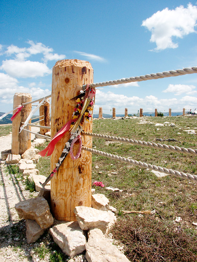
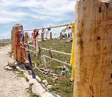 I found the prayer flags fascinating and no two were alike. I
can only imagine what significance they hold and what the maker
was trying to symbolize using the different construction materials.
Some were like actual flags while others were little satchels
filled with something? Bones, feathers, cloth and other organic
materials were used in the making. Fascinating and beautiful.
I found the prayer flags fascinating and no two were alike. I
can only imagine what significance they hold and what the maker
was trying to symbolize using the different construction materials.
Some were like actual flags while others were little satchels
filled with something? Bones, feathers, cloth and other organic
materials were used in the making. Fascinating and beautiful.
 One possible explanation? "A contemporary Cheyenne cultural leader
stated, "the tribes traditionally went and still do go to the
sacred mountain. The people sought the high mountain for prayer.
They sought spiritual harmony with the powerful spirits there.
Many offerings have been left on this mountain. The center cairn,
once occupied by a large buffalo skull, was a place to make prayer
offerings. Vision questors would have offered prayers for thanks
for plant and animal life that had, and would, sustain them in
the future. Prayers of thanks were offered for all of creation.
Prayers are made for families and loved ones who are ill. Atonements
are made for any offense to Mother Earth. When asking for guidance,
prayers for wisdom and strength are always part of this ritual.
All of this is done so that spiritual harmony will be our constant
companion throughout the year."
One possible explanation? "A contemporary Cheyenne cultural leader
stated, "the tribes traditionally went and still do go to the
sacred mountain. The people sought the high mountain for prayer.
They sought spiritual harmony with the powerful spirits there.
Many offerings have been left on this mountain. The center cairn,
once occupied by a large buffalo skull, was a place to make prayer
offerings. Vision questors would have offered prayers for thanks
for plant and animal life that had, and would, sustain them in
the future. Prayers of thanks were offered for all of creation.
Prayers are made for families and loved ones who are ill. Atonements
are made for any offense to Mother Earth. When asking for guidance,
prayers for wisdom and strength are always part of this ritual.
All of this is done so that spiritual harmony will be our constant
companion throughout the year."
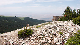
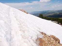 I had the place almost to myself and this is the reason why. It
was necessary to walk the last mile and a half to the top of the
mountain. At one point on the road up there was a large snow field
covering a couple hundred feet of the path. The snow itself was
at about a 40 degree angle or so and dropped down the side of
the mountain a couple of hundred feet. If heights bothered you
then this would not be a place you would want to go for a casual
stroll. If happened to slip you would go quite a ways before something
hard like a tree stopped your motion. A trail had been stamped
in the snow, though, and it was really quite easy to navigate
if you were willing to try it. Most people turned around and headed
back to their cars. In fact almost no one was willing to walk
these couple of hundred feet so once I reached the top I was nearly
alone. There was one old woman and one old man (native americans)
at the top that had to be at least in their 70s if not older.
Apparently they were not afraid of heights.
I had the place almost to myself and this is the reason why. It
was necessary to walk the last mile and a half to the top of the
mountain. At one point on the road up there was a large snow field
covering a couple hundred feet of the path. The snow itself was
at about a 40 degree angle or so and dropped down the side of
the mountain a couple of hundred feet. If heights bothered you
then this would not be a place you would want to go for a casual
stroll. If happened to slip you would go quite a ways before something
hard like a tree stopped your motion. A trail had been stamped
in the snow, though, and it was really quite easy to navigate
if you were willing to try it. Most people turned around and headed
back to their cars. In fact almost no one was willing to walk
these couple of hundred feet so once I reached the top I was nearly
alone. There was one old woman and one old man (native americans)
at the top that had to be at least in their 70s if not older.
Apparently they were not afraid of heights.
 I ended up getting lunch at a Lodge at Burgess Junction. I fell
in love for the second time this trip with my waitress. She was
this cute little blonde and had all the attributes I look for
in a woman and in all the right places. Why do they all have to
be 15 years younger than I am and live 10 states away??? (hehe)
I got the BIG burrito and might have possibly finished
it if I hadn't been saving room for the pie everybody was bragging
about. I tried some mystery type but have forgotten the name.
The waitress wasn't even sure what was in it. It was some mixture
of about six different berries and I do remember it was very good.
I ended up getting lunch at a Lodge at Burgess Junction. I fell
in love for the second time this trip with my waitress. She was
this cute little blonde and had all the attributes I look for
in a woman and in all the right places. Why do they all have to
be 15 years younger than I am and live 10 states away??? (hehe)
I got the BIG burrito and might have possibly finished
it if I hadn't been saving room for the pie everybody was bragging
about. I tried some mystery type but have forgotten the name.
The waitress wasn't even sure what was in it. It was some mixture
of about six different berries and I do remember it was very good.
I headed northeast on 14A but was delayed for awhile in the
mountains due to an accident. It occurred on one of the sharper
turns and involved a rented RV and a pickup truck. Looking at
the wreckage it appeared to be a near head-on collision and the
right side front of both vehicles was in pretty bad shape. I don't
know the status of the occupants but it couldn't have been good.
 After about half an hour the road was cleared but now there was
this long line of slow moving traffic and I soon decided
that I needed an alternate route. After looking at the map and
the GPS I found a dirt road out of Dayton that ran, unpaved, for
about 40 miles and headed southeast. After two full weeks on the
bike I was getting pretty comfortable on the looser surfaces and
made good time. I only saw about 3 or 4 cars the entire distance.
After about half an hour the road was cleared but now there was
this long line of slow moving traffic and I soon decided
that I needed an alternate route. After looking at the map and
the GPS I found a dirt road out of Dayton that ran, unpaved, for
about 40 miles and headed southeast. After two full weeks on the
bike I was getting pretty comfortable on the looser surfaces and
made good time. I only saw about 3 or 4 cars the entire distance.
This road took me to I-90 which I then took to Buffalo. It didn't
take me long to find a place to set the tent up and I then grabbed
a book and settled down for the night. It was an enjoyable day
but due to the low mileage I will have to make up some lost time
tomorrow.
|