 Ride, ride, and ride some more. I left Tuttle Creek SP at about
9:30. I am going to have to adjust to being back in the Central
time zone. I never bothered to change my clocks so I was used
to it getting dark at about 22:00 and I could sleep in until 9:00
because it was really only 8:00. No more.
Ride, ride, and ride some more. I left Tuttle Creek SP at about
9:30. I am going to have to adjust to being back in the Central
time zone. I never bothered to change my clocks so I was used
to it getting dark at about 22:00 and I could sleep in until 9:00
because it was really only 8:00. No more.
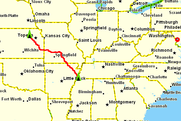
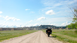
I took Hwy 99 south until I reached Hwy 31 just past Eskridge.
The day was sunny and I could tell it was going to be another
hot one. There were a few clouds in the sky but it was a gorgeous,
bright blue for the most part.
 Hwy
31 ran with 75 for a ways south and then branched off east. I
checked the map and the gps to determine where to turn and which
roads to take. If you set a waypoint as a destination on the gps
and have the bearing line on and the course line off you see a
nice green line directly from your current position to your destination.
For the last couple of days I have had my house in Alabama set
as my destination so determining which roads to take is as easy
as choosing ones closest to the drawn bearing line and heading
in the same direction. This usually means that my path resembles
a staircase since the roads never seem to head "exactly"
the direction I wish to go. Hwy
31 ran with 75 for a ways south and then branched off east. I
checked the map and the gps to determine where to turn and which
roads to take. If you set a waypoint as a destination on the gps
and have the bearing line on and the course line off you see a
nice green line directly from your current position to your destination.
For the last couple of days I have had my house in Alabama set
as my destination so determining which roads to take is as easy
as choosing ones closest to the drawn bearing line and heading
in the same direction. This usually means that my path resembles
a staircase since the roads never seem to head "exactly"
the direction I wish to go.
 I
picked up 59 south in Garnett which then took me to 54. I took
54 east across the Missouri state line until I reached Hwy 32.
I didn't remember to write it down so my facts are a bit hazy
but I believe I was riding into a town on 32 when I thought to
myself that the place was a dump. Garbage and debris were strewn
everywhere and I wondered why the people didn't do something about
the mess. As I rode further I noticed that some of the buildings
were even trashed and I thought to myself that the place looked
like a tornado had come through. That cliche popped into my mind
but as I continued I saw a swath of destruction and realized that
a tornado had gone through the place. People
were doing the best they could to rebuild but there was still
lots of work to do. I believe the town was Stockton but I could
be wrong. I
picked up 59 south in Garnett which then took me to 54. I took
54 east across the Missouri state line until I reached Hwy 32.
I didn't remember to write it down so my facts are a bit hazy
but I believe I was riding into a town on 32 when I thought to
myself that the place was a dump. Garbage and debris were strewn
everywhere and I wondered why the people didn't do something about
the mess. As I rode further I noticed that some of the buildings
were even trashed and I thought to myself that the place looked
like a tornado had come through. That cliche popped into my mind
but as I continued I saw a swath of destruction and realized that
a tornado had gone through the place. People
were doing the best they could to rebuild but there was still
lots of work to do. I believe the town was Stockton but I could
be wrong.
Another odd thing I saw on Hwy 32 was about 30-40 Model A Fords.
There was obviously a show or rally somewhere and the drivers
and their passengers were in their Sunday's finest with suits
and dresses, hats and scarfs. It seems only older folk have the
time, money, and the appreciation it takes to collect and restore
cars like that.
 I
continued on 32 southeast all the way to Lynchburg and the Mark
Twain National Forest. If I had decided to split my route to Alabama
into two days this is where I would have stopped and camped. It
was about 16:00 when I got there and I actually pulled over and
took the road atlas out so I could decide on a route and whether
or not I wanted to continue for the day. I decided that I would
keep going, fired the bike back up, and headed south on 95
until 60 where I turned left and headed east. 60 and 63 run together
for a short while before 63 heads southeast for a long ways and
into Arkansas. It then continues all the way to I-55 which I took
into Memphis. It was dark and it was obvious that there had been
a good deal of rain earlier so the roads were wet and the trucks
were throwing up large amounts of water. I stayed on I-55 just
long enough to find a place to sleep. This put me within one easy
day's ride of my next stop, Birmingham, Alabama. I
continued on 32 southeast all the way to Lynchburg and the Mark
Twain National Forest. If I had decided to split my route to Alabama
into two days this is where I would have stopped and camped. It
was about 16:00 when I got there and I actually pulled over and
took the road atlas out so I could decide on a route and whether
or not I wanted to continue for the day. I decided that I would
keep going, fired the bike back up, and headed south on 95
until 60 where I turned left and headed east. 60 and 63 run together
for a short while before 63 heads southeast for a long ways and
into Arkansas. It then continues all the way to I-55 which I took
into Memphis. It was dark and it was obvious that there had been
a good deal of rain earlier so the roads were wet and the trucks
were throwing up large amounts of water. I stayed on I-55 just
long enough to find a place to sleep. This put me within one easy
day's ride of my next stop, Birmingham, Alabama.

|